INDIANA – The first new portion of I-69 in Marion County is expected to open for traffic this week. The opening will kick off a series of temporary and permanent traffic pattern changes needed to complete the construction of the limited-access interstate.

Southbound S.R. 37 traffic shift
Southbound State Road 37 traffic is expected to shift on or after Thursday, May 26 to the elevated pavement and bridges between Southport Road and Fairview Road in Johnson County. Southbound traffic will not stop for traffic signals at Wicker Road and County Line Road.
New access west of S.R. 37
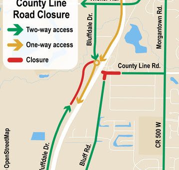
New southbound S.R. 37 entrance and exit ramps at County Line Road will open to a large roundabout west of the new highway.
A new section of Bluffdale Drive will connect this roundabout to and from Wicker Road to the north. Another new section of Bluffdale Drive is expected to open in early June connecting County Line Road to Fairview Road.
Northbound S.R. 37 traffic shift
Northbound S.R. 37 traffic is expected to shift to the new elevated pavement and bridges on or after late next week. Two-way S.R. 37 traffic will be divided by temporary barriers during the construction of the new I-69 northbound lanes.
S.R. 37 northbound traffic will not stop at Wicker Road and County Line Road. Local access points to and from S.R. 37 northbound in the area will be at the Fairview Road and Southport Road traffic signals.
County Line Road closure
The new I-69 interchange is realigning County Line Road slightly north to minimize traffic impacts during construction. As each direction of S.R. 37 shifts to the new traffic pattern, access to County Line Road and its nearby intersection with Bluff Road are expected to close temporarily for about two months.
During the closure, construction crews will build the new County Line Road alignment underneath the future I-69 bridges and a large roundabout. The roundabout will connect the future I-69 northbound ramps with the existing Bluff Road and County Line Road.
Traffic access maps
The County Line Road area is one of many along existing S.R. 37 and I-465 that will be affected by changing traffic patterns for I-69 Finish Line construction.
To help plan safe summer travels, the project offers a graphical map that can be printed for directions or an interactive Traffic Access Map on the project website. The maps put localized traffic patterns into the context of other local roads and the larger I-69 Finish Line project.


