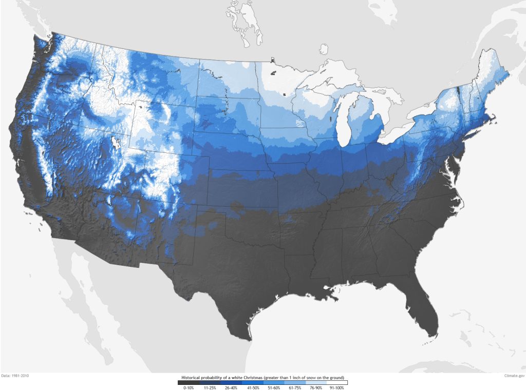
INDIANA – As Christmas approaches, early forecasts predict a much warmer holiday season for much of the United States. Temperatures are expected to peak around 10 to 15 degrees above normal on Christmas Day, a trend that mirrors last year’s holiday weather. Last Christmas marked one of the warmest winters nationwide; this year could follow a similar pattern.

The last white Christmas for Indiana occurred in 2022, leaving many hoping for a similar winter scene this year. However, those dreams may have to wait as temperatures remain high and snow chances appear slim.
Here are a few snow extremes from Christmas Day:
| Greatest Snowfall on Christmas Day | Greatest Snow Depth on Christmas Day |
| 5.9” in 1909 | 9” in 2004 |
| 4.4” in 1926 | 7” in 2002 |
| 3.3” in 1890 | 7” in 1909 |
| 2.6” in 2005 | 6” in 1995 |
| 2.4” in 1935 | 6” in 1935 |
Indiana could see colder air leading toward Christmas Day. Maybe a mix of upper 20s to low 40s. The coldest air should stay well to the north.
A few temperature and precipitation extremes:
| Warmest Max Temp | Coldest Max Temp | Warmest Min Temp | Coldest Min Temp | Most Precipitation |
| 64 in 1893 | -4 in 1983 | 55 in 1877 | -15 in 1983 | 1.36 in 2005 |
| 63 in 1982 | 7 in 1985 | 50 in 1889 | -5 in 2000, 1878 | 1.14 in 1957 |
| 63 in 1889 | 10 in 1924 | 45 in 1982 | -4 in 1935, 1924 | 0.98 in 1982 |
| 62 in 2019 | 13 in 1884 | 44 in 1888 | -3 in 2004, 1980 | 0.72 in 2006 |
| 59 in 1877 | 14 in 1980, 1902 | 42 in 1940, 1936, 1895, 1891 | -2 in 1872 | 0.61 in 1926 |
In a pattern like this, there may be some scattered, weaker lake-effect snow showers, but that would most likely keep snow chances or white Christmas chances in place for far northern Indiana, not so much central Indiana.
All major global models have a 5-30% chance of snow showers across Indiana. Lawrence County has a 10% chance of snow.
The last white Christmas for Indiana occurred in 2022, leaving many hoping for a similar winter scene this year. However, those dreams may have to wait as temperatures remain high and snow chances appear slim.
Indiana could see colder air leading toward Christmas Day. Maybe a mix of upper 20s to low 40s. The coldest air should stay well to the north.
In a pattern like this, there may be some scattered, weaker lake-effect snow showers, but that would most likely keep snow chances or white Christmas chances in place for far northern Indiana, not so much central Indiana.
All major global models have a 5-30% chance of snow showers across Indiana. Lawrence County has a 10% chance of snow.
In areas north of Interstate 70, the chances for warmer-than-usual temperatures are estimated at 26 to 40%. In southern Indiana, however, the likelihood drops to between 11% and 25%. In addition to the unseasonably warm temperatures, the forecast indicates that much of the country will experience drier-than-normal conditions during the weekend leading up to Christmas, which means there will be less snow in many regions.
Meteorologists note that for a Christmas to be officially considered “white,” there must be at least one inch of snow on the ground on December 25. Given the current dry forecast, many locations, including parts of Indiana, may miss out on this traditional holiday feature.
However, a brief cooldown is expected toward the end of the week and into the weekend. While snow flurries can’t be ruled out, the key issue will be the temperatures. Even if snow does fall, temperatures are expected to rise quickly in the days leading up to Christmas, likely melting any snow before it can accumulate.


