

INDIANA— On Monday, Beryl made landfall in Texas as a Category One hurricane.
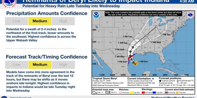
Beryl’s current trajectory is taking a northern trajectory, which would see it reach Indiana as a tropical depression and bring heavy rainfall.
The National Weather Service Indianapolis says Beryl’s path could still be altered. Still, at this point, they are anticipating several inches of rain late Tuesday night and most of Wednesday. The Upper Wabash Valley will receive the most rain, with Lafayette seeming like the biggest target for central Indiana.
The NWS forecasts 2-4 inches of rain across Indiana. By Thursday, the rain should move out into Ohio.
With the rainfall will also come cooler temperatures. Monday’s expected high of 90 will be paralleled by a high of only 75 on Wednesday. Relief will be temporary, however, as things are expected to heat up, reaching 90 again by the weekend.
The NWS advises caution as Beryl passes through Indiana heavy rainfall can cause hazardous road conditions for drivers at all times of day, but especially at night when the rain is expected to arrive. High sustained winds could also be a factor.

